
On Your Bike!: New mobile app for mountain biking launched
 Last Saturday we launched our first iPhone app on behalf of Denbighshire County Council. It’s part of the suite of web and mobile applications we’ve developed for the Ride North Wales brand (click here for the main website) that promote North Wales as an exciting hub for on and off-road cyclists of all levels of ability. The hub covers routes and amenities through the Conwy Valley, Hiraethog and the Clwydian Range.
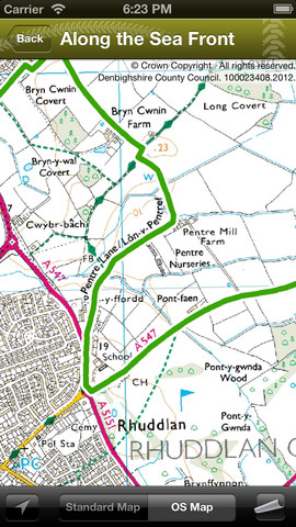
The app is free and can be downloaded from the iTunes website if you click here. The app builds on the data and content in the central database and CMS that supports the main website and features routes shown on the native mapping of the iPhone and on Ordnance Survey (OS) mapping.
The OS route maps have been optimised for use in conjunction with the iPhone’s GPS which means that even if cyclists can’t connect to the Internet to see routes on Apple maps they will be able to use the GPS in conjunction with the bundled OS route maps. In addition there are route cards that can be downloaded as further back-up.
The app also features places to eat and stay, local hire shops and bike facilities as well as location points for tourist information, first aid and public transport.
Plans are already in place for version 2.0 but with the launch of verion 1.0 we’re hoping to get some user feedback to help us refine and prioritise some of our ideas and technical solutions. [more]
There are also plans to extend the Ride North Wales hub to include graded road cycling routes in addition to the Easy, Moderate, Hard and Very Hard mountain biking routes already mapped. The development team are also looking at improving how the interactive maps can carry more information via waymarkers on the route maps and a function to help cyclists and app users identify what amenities are in their proximity while on or near the route.
This is an exciting development for us at the Portal so we’d welcome any feedback either via the blog or the iTunes store!